Severe Weather Awareness Week continues with probably the most frequent culprit for our local area: severe thunderstorms.
Severe thunderstorms are not as destructive as a tornado, but they happen at a higher frequency, affecting more people and communities across the region.
Due to our local terrain, slopes, and tree coverage, damage to trees can happen at wind speeds of 40 mph. That speed is 20 mph below severe thunderstorm level.
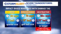
The National Weather Service issues severe thunderstorm warnings when storms produce a baseline level for wind and hail. Developed in 2021, warnings are now given at three levels with damage taglines.
The traditional “Base” severe thunderstorm has wind at 58 mph (rounded up to 60 mph in warnings) or 1”hail, which is the size of a quarter. The storm may have both the wind and hail or just one of them.
Here in the Tennessee Valley, our main contributor to trigger severe thunderstorm warnings is wind reaching 60 mph. This baseline warning is the most common locally.
The next step up is “Considerable” with 70 mph wind and/or golf ball size hail (1.75”). Both those wind speeds and hail will increase the potential damage to trees, siding, roofs, and powerlines.
The third level is “Destructive.” A Destructive severe thunderstorm will have wind at 80+ mph or hail at 2.75” or larger. That’s hail the size of a baseball. Because damage can be devastating at those levels, a Destructive severe thunderstorm warning will trigger a Wireless Emergency Alert to be sent to your phone, like a tornado warning does.
No matter the warning level, each means the severe storm is imminent, and you should take action. Particular caution should be used for the Considerable or Destructive warnings.
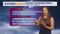
Severe thunderstorms will form in a variety of weather setups. Two frequent ones are squall lines and summertime convective storms.
As outdoor activities increase this spring and summer, please remain weather aware for severe thunderstorms.


